


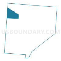
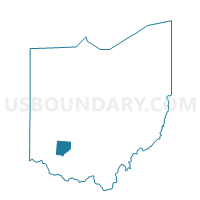
PRECINCT CHESTER B, Clinton County, Ohio
About
Outline

Summary
| Unique Area Identifier | 643644 |
| Name | PRECINCT CHESTER B |
| County | Clinton County |
| State | Ohio |
| Area (square miles) | 15.64 |
| Land Area (square miles) | 15.48 |
| Water Area (square miles) | 0.17 |
| % of Land Area | 98.94 |
| % of Water Area | 1.06 |
| Latitude of the Internal Point | 39.49402430 |
| Longtitude of the Internal Point | -83.94764280 |
Maps

Graphs
Select a template below for downloading or customizing gragh for PRECINCT CHESTER B, Clinton County, Ohio


Neighbors
Neighoring Voting District (by Name) Neighboring Voting District on the Map
- 0065 HARVEYSBURG VIL Voting District, Warren County, OH
- 0066 MASSIE TWP Voting District, Warren County, OH
- PRECINCT ADAMS A, Clinton County, OH
- PRECINCT CHESTER A, Clinton County, OH
- PRECINCT UNION NORTH A, Clinton County, OH
- PRECINCT UNION NORTH B, Clinton County, OH
Top 10 Neighboring County Subdivision (by Population) Neighboring County Subdivision on the Map
- Union township, Clinton County, OH (3,085)
- Adams township, Clinton County, OH (2,091)
- Chester township, Clinton County, OH (1,967)
- Massie township, Warren County, OH (1,141)
Top 10 Neighboring Place (by Population) Neighboring Place on the Map
Top 10 Neighboring Unified School District (by Population) Neighboring Unified School District on the Map
Top 10 Neighboring State Legislative District Lower Chamber (by Population) Neighboring State Legislative District Lower Chamber on the Map
Top 10 Neighboring State Legislative District Upper Chamber (by Population) Neighboring State Legislative District Upper Chamber on the Map
Top 10 Neighboring 111th Congressional District (by Population) Neighboring 111th Congressional District on the Map
Top 10 Neighboring Census Tract (by Population) Neighboring Census Tract on the Map
- Census Tract 9645, Clinton County, OH (6,300)
- Census Tract 9644, Clinton County, OH (5,087)
- Census Tract 311, Warren County, OH (3,858)